Pennsylvania College of Technology's Pennsylvania Society of Land Surveyors student chapter recently took part in a service project involving the National Geodetic Survey, collecting data to correct insufficient and inaccurate Global Positioning System information.
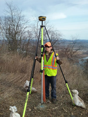 "The members of the club collected GPS data on the benchmark for 4½ hours, then submitted the data to the NGS," said chapter President Mark A. Valchar, of Huntingdon County, set to graduate in May with an associate degree in surveying technology. "If the data is acceptable (it was), it is then included in the calculations for the new geoid model and becomes part of the National Spatial Reference System."
That system, the ongoing product of more than 200 years of collaboration between the public and private sectors, is relied upon by surveyors and other professionals to ensure that positional coordinates – more than 1.5 million of them – are precise and compatible during the job at hand: creating maps; delineating property boundaries; or planning, designing and building roads and bridges.
Penn College students have participated in the project for several years in conjunction with the spring observance of National Surveyors Week.
The School of Construction & Design Technologies' related majors, two- and four-year degrees in civil engineering technology and an associate degree in surveying technology, are accredited by the Engineering Technology Accreditation Commission of ABET.